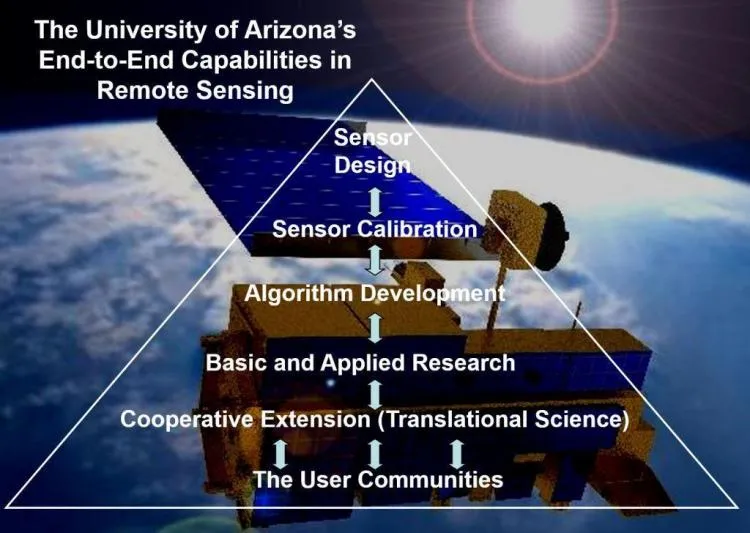
The University of Arizona offers a unique opportunity to pursue a multidisciplinary Ph.D. minor degree in remote sensing and related fields in spatial analysis. The breadth and depth of courses offered in these fields is unmatched by any other institution.
Our academic program covers all aspects of remote sensing and spatial analysis, including:
- The fundamentals of the physics and optics of remote sensing
- The fundamentals of cartography, particularly in the digital representation and manipulation of maps
- The tools of remote sensing and spatial analysis such as image processing, pattern recognition, geostatistics and geographic information systems, and
- The application of remote sensing and spatial analysis in the fields of agriculture, anthropology, astronomy, engineering, geography, geology, hydrology, planetary sciences, and renewable natural resources.
Although there are no formal minor degrees offered at the Masters level, students may take any of the courses listed below as part of their academic program. The curriculum is supplemented by numerous funded research projects in both applied and basic aspects of remote sensing.
A graduate student wishing to minor in remote sensing and spatial analysis may major in any field. Two options are available to accommodate the diversity of backgrounds and interests among students interested in remote sensing and spatial analysis. The first option is Remote Sensing Science, which is intended to meet the needs of students concerned with the basic nature of remote sensing. The second option, Spatial Analysis, is intended to serve students interested in remote sensing and spatial analysis as tools in their discipline.

The University of Arizona is widely known for its research program in remote sensing and spatial analysis. Within NASA’s Earth Observing System (EOS) program, the University boasts the largest number of principal investigators among all participating universities.
As a result of this high level of research activity, opportunities and financial support for dissertation research in remote sensing and spatial analysis exist in several departments at the University. Campus units particularly active in remote sensing and spatial analysis are the Advanced Resource Technology Group (ART, School of Renewable Natural Resources), Arizona Remote Sensing Center (ARSC, Office of Arid Lands Studies), the Digital Image Analysis Laboratory (DIAL, Electrical and Computer Engineering), the Institute of Atmospheric Physics, Institute for the Study of Planet Earth, Mining and Geological Engineering, the Planetary Image Research Lab (PIRL, Planetary Science), the Remote Sensing Group (RSG, Optical Sciences), Department of Soil and Water Science, and the Spatial Analysis Laboratory (SAL, Geography and Regional Development).
Recent research projects have included:
- Arizona Regional Image Archive
- Validation and correction for the EOS MODIS spatial response
- Utilization of EOS data in quantifying processes controlling the hydrologic cycle in arid/semiarid regions
- Absolute radiometric calibration of TM, SPOT, AVHRR, and AVIRIS
- Famine Early Warning System (FEWS) for Africa
- Environmental support of nomads in the Kingdom of Saudi Arabia
- Environmental monitoring system for Malawi
- Remote sensing database browsing using high performance computers and networks
- Neural networks classification algorithms for remote sensing
- Spatial analysis of wildfire behavior in the Southwest
- Origins of Venus channels, valleys and related phenomena
- Satellite determination of ozone with the SBUV/TOMS instrument
- Satellite determination of aerosols, ozone, water vapor with SAGE III
- Satellite determination of pressure, density, and temperature using GPS data
